
Landslide
Landslide risk in Barbados is generally limited to the Scotland District, which contains very different soil types to the remainder of Barbados. Landslide hazards were evaluated based on soil properties and slope angles, Defining slope risk is not a precise science since it depends on accurate depiction of soil characteristics and definition of these characteristics through depth. Slope stability is classified as low, medium and high based on local slope angle, and the soil properties associated with different regions.
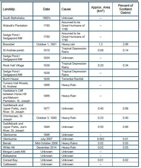
Landslide damage may occur as a result of large slides (perhaps one square kilometer or more in area), smaller localized issues, or gradual creep of hillsides. For this assessment of financial impacts, long term creep will not be considered as it is considered a maintenance issue, in much the same way that other elements can cause long term degradation of structures. The landslide hazard is described in the Hazard report (Baird, 2017a), and defines the slope stability throughout the Scotland district on soil types and ground slope.
Identificación de fuentes sísmicas
Caracterización del potencial de generación de terremotos de cada fuente
Modelación de la distribución de la intensidad sísmica como una función de la magnitud y la distancia
Aplicación de la teoría de la probabilidad
- ...
- For each soil type, surface slopes were assessed to define whether regions were at low, medium or high probability of slope failure based on a factor of safety analysis.
- The landslide hazard is described in the Hazard report (Baird, 2017a), and defines the slope stability throughout the Scotland district on soil types and ground slope.
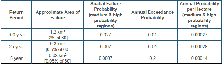
Strictly speaking, any slope that has a FoS less than one should fail. However, this assumes that soils are consistent and accurately defined, which an unrealistic expectation is some of the steepest slopes in the Scotland District have a factor of safety closer to 0.5, which implies that there are locally variable conditions on the surface and/or at depth that are influencing the stability of these slopes. These local variations mean that accurately predicting where failures will occur is almost impossible. It should be noted that the possible return period associated with large failure events (such as Boscobel) may be unreliable because it is based on only one event
Landslide risk in Barbados is evaluated on a structure by structure basis, rather than completing the assessment for a land parcel. Some land parcels are large and have multiple structures, which makes the assumption of loss of a full parcel inappropriate.
Each structure is tabulated to define how much of the improved value of the parcel is allocated to the structure, which was assumed to be proportional based on the structure area.
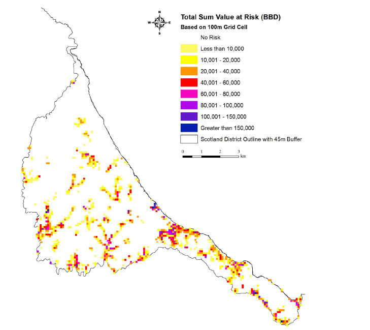
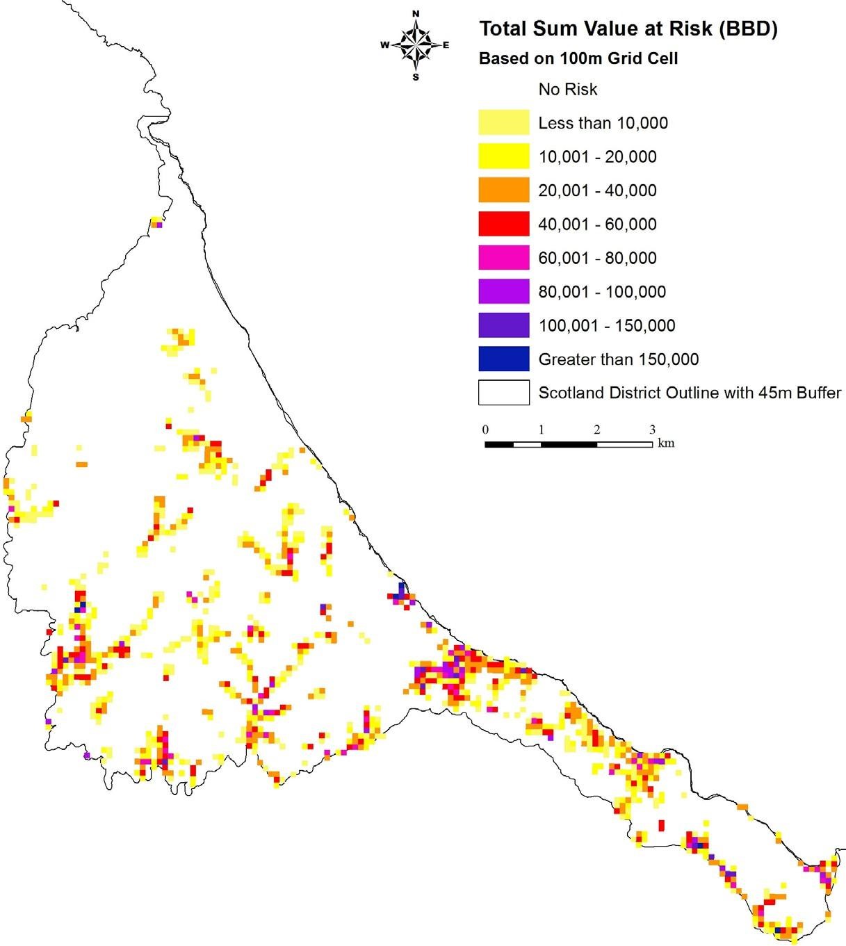
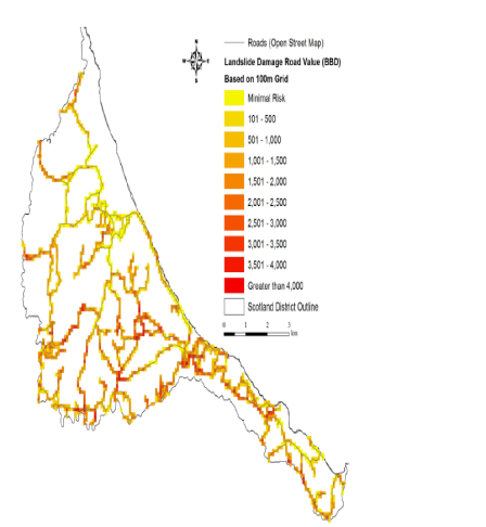
Tabulation of risk due to landslides in Barbados uses a 100 m grid spacing that is consistent with the manner that risk is quantified for other hazards.
0.0: A zero value is assigned to assets in regions that are categorized as low failure probability
0.5: This value is assigned for regions that are quantified as medium failure probability
1.0: Any structure that is in a region of high failure probability would be expected to have a complete loss of the
structure in the event of a landslide.
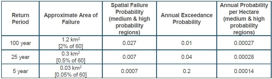
Regions that are gradually deteriorating may result in the abandonment of structures, thereby reducing the chance of loss of life. If we assume that all high and medium failure probability regions of the Scotland District are (approximately) equally exposed, then the mortality probability for an individual living in one of these regions is expected to be similar, or less, since people may leave an area if landslide warning signs appear. The number of structures expected to be affected by the 5, 25 and 100 year landslides is 4, 40 and 160, respectively. This would likely include a blend of residential and other structures, and some of these may be abandoned prior to failure.
- ...
- ...
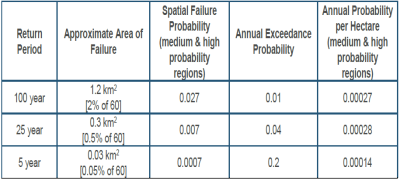
- The size of the 100 year event is roughly assigned based on the Boscobel failure from 1901.
- Strictly speaking, all of the Scotland District is exposed, although some areas are much lower failure probability than others …
- ...
- ...
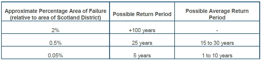
Historical landslide information was assessed, and an estimate of the area associated with different return period events was developed. The largest of known historical events was used as guidance in estimating the 100 year event, in which an estimated 2% of the Scotland District may fail. There are significant uncertainties in these estimates; however, they provide general guidance for assessing overall risk. The risk to structures in the Scotland District is based on having building assets in medium or high risk areas; buildings in areas listed as “low” were not considered in the risk assessment. Each building that is medium or high risk is then assigned a spatial probability of being part of a particular X-year landslide event.
- ...
- ...
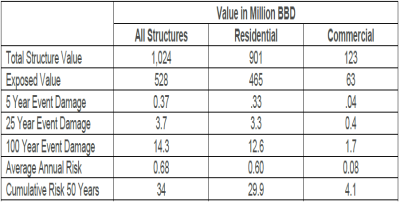
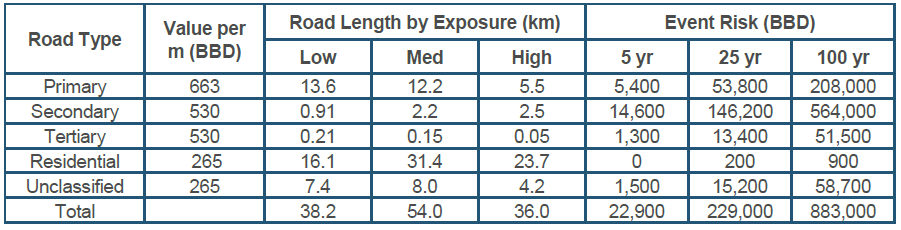
- Residential buildings and possible landslide damage amount to about 90% of the risk in the Scotland District. If a 100 year slide impacted a more or less developed area, the damages could be minimal, or could be many times higher than the predicted value.
- The risk is defined by the intersection of medium and high probability slope failure areas with structural assets.
- ...
- ...