
Gale-force Wind
The risk associated with extreme winds is one of the greatest risks faced by Barbados; this was strongly demonstrated through the extreme hurricane damage in the northern Caribbean during the 2017 hurricane season. Unlike other hazards in the NCRIPP, winds can be a factor island-wide, regardless of proximity to the coast or whether a structure is near a watercourse (as per water-based hazards).
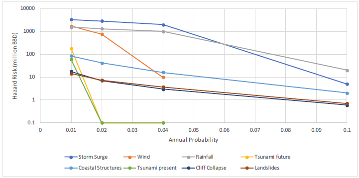
The wind hazard was assessed during the hazard assessment phase of the NCRIPP study (Baird, 2017a), and focused on hurricane events in the vicinity of Barbados. Rather than assessing only historical storm events that directly impacted Barbados, statistics were tabulated throughout the region of the tropical Atlantic Ocean near Barbados, and a Monte Carlo methodology was undertaken to examine hypothetical storm events. Using the historical statistics in the region, approximately 900 storms were generated using a hurricane vortex model and gridded wind fields. From each of these events, time series of the winds in Barbados were extracted and extreme value analyses were undertaken to provide estimates of various wind speed return period events.
Identificación de fuentes sísmicas
Caracterización del potencial de generación de terremotos de cada fuente
Modelación de la distribución de la intensidad sísmica como una función de la magnitud y la distancia
Aplicación de la teoría de la probabilidad
- ...
- ...
- The wind hazard in Barbados is applied equally across Barbados, in that there is no net trend in the possible wind speeds from north to south, or east to west.
- The wind exposure in the vicinity of Barbados is essentially equal throughout the area; all regions of Barbados are thus assumed to have the same design wind speeds, regardless of proximity to the coast or local land profile.
- The potential for severe wind damage in Barbados is high.
- Wind damage may be severe at higher wind speeds but drops off quickly as the wind speed reduces. Local building practice and conformance to standards (both past and future) will affect the threshold at which significant damage starts to occur.
The wind damage analysis uses the wind speed return periods that were identified in the Hazard Report (Baird, 2017a). These wind speeds are defined in metres per second (m/s) and considered to be the maximum three second gust value. Wind speeds used for assessing storm surge and wave generation are typically based on longer duration averages (such as a 10 minute average); however, structure damage will occur in response to much shorter duration and strong gusts. Damage is assessed for buildings that are defined from both the LiDAR information, and a range of other information sources.
Damage is assessed for buildings that are defined from both the LiDAR information, and a range of other information sources.
The measured housing stock data provides detailed housing information and the modelled housing stock and Census data interpolate the data to the Enumeration District level.
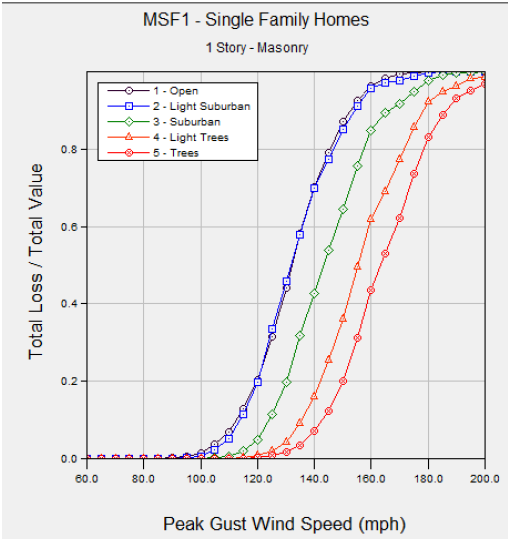
The wind damage function is derived from Emanuel (2011), which calculates the fraction of structure value damage incurred at a given peak gust wind speed.
The wind speed at which a structure experiences 50% damage (vhalf) is dependent on the housing characteristics and the terrain roughness.
The vhalf parameters are derived in the FEMA HAZUS software Hurricane Module. The software provides damage functions for various houses based on characteristics most vulnerable to wind damage. The graphs show the fraction of a given structure damaged at different winds speeds
The wind exposure in the vicinity of Barbados is essentially equal throughout the area; all regions of Barbados are thus assumed to have the same design wind speeds, regardless of proximity to the coast or local land profile. The vulnerability to wind damage was based on statistical information describing the building parameters, which introduced spatially varying vulnerability to the wind hazard.
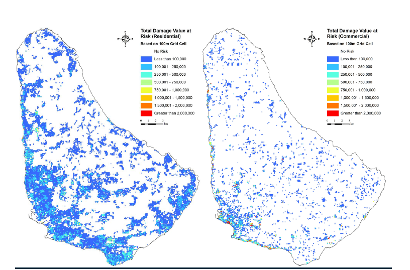
Damage was assessed for all structures in Barbados, and catalogued as damage to either a residential or commercial structure. Damage that can be linked to specific structures must consider that structure-specific susceptibility information was not available for these analyses.
- ...
- ...
- ...
- Commercial damage is estimated to be approximately BBD 660 million, which represents just over 5% of the commercial structure value in Barbados. Content losses are not included in this estimate.
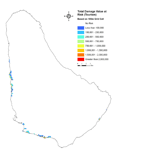
- Wind damage to the tourism sector is a subset of the commercial sector and was computed at BBD 270 million for the 100 year wind event
- In a 100 year event, damage is widespread throughout Barbados, and closely follows the distribution of the housing stock.
- Residential housing stock totals approximately BBD 29 billion, and damage estimates are approximately BBD 1.0 billion, or about 3.6% of the total residential value.
The wind hazard in Barbados is applied equally across Barbados, in that there is no net trend in the possible wind speeds from north to south, or east to west. There is also no differentiation in the wind exposure from being on the coast versus at some distance inland, as the distances within Barbados are all sufficiently small. The vulnerability assessment therefore used a consistent wind exposure and some statistical information on the building parameters, which introduced spatially varying vulnerability.
Climate change has not been examined for the wind hazard. There is low confidence in the long term impacts of climate change on the extreme hurricane wind speeds, as this is not only a question of storm intensity, but also of frequency and track.
- ...
- ...
- ...
- In the hazard assessment this level of detail was not applied. The risk assessment for the housing stock assessment has revisited the assumption of applying consistent exposure throughout Barbados
- There are undoubtedly some locations that are more or less exposed to winds in Barbados as a result of very localized site conditions.
- The available data does not show whether a structure is newly constructed to meet the latest codes, or poorly designed/maintained to outdated standards. Consequently, reporting of individual asset level information is not appropriate.