
Earthquake
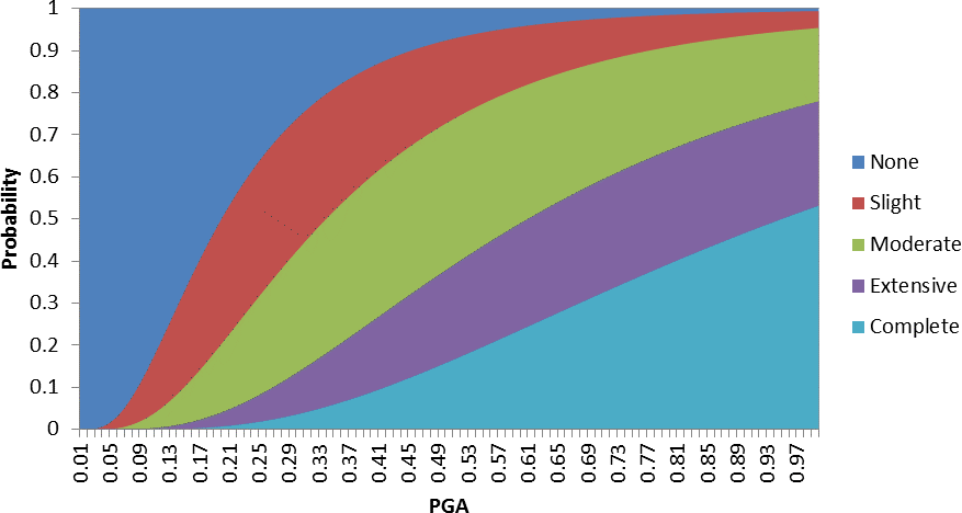
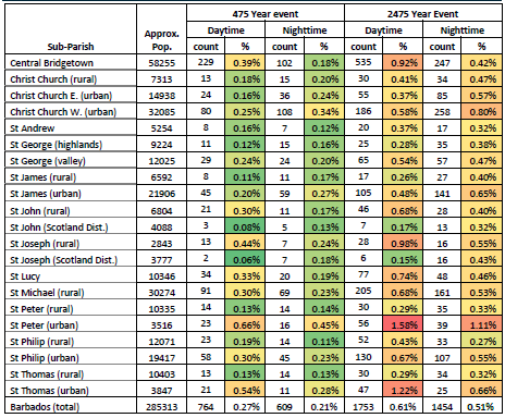
Damage levels due to seismic hazard were determined based on the probability of five damage states, ranging from “none” (no damage to structure) to “complete” (100% damaged), for a given building type and peak ground acceleration (PGA) value from the HAZUS technical manual. The damage levels in Barbados are extreme from these higher return period events. Losses are significantly influenced by the assumed level of code adherence in Barbados. Mapping is undertaken based on a low code adherence, although this may be somewhat conservative.
The limited historical strong seismic activity in Barbados has two implications: Regions with less historical seismic activity may have reduced seismic resistance in their structures, since it was not a major consideration for many designers and builders. Often, it is only after larger events, or some other scientific realization, that improved designs are implemented. The quality of construction and resistance to ground acceleration is not well understood in Barbados, other than through learning from other locations. The other complication in assessing the seismic damage in Barbados is the limited information regarding the construction of buildings. There is limited structural information.
Identificación de fuentes sísmicas
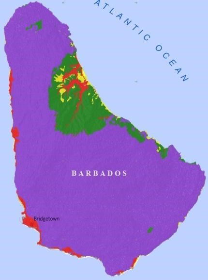
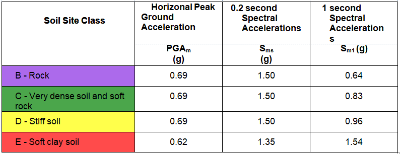
- B - Rock
- C - Very dense soil and soft rock
- D - Stiff soil
- E - Soft clay soil
Caracterización del potencial de generación de terremotos de cada fuente
Structure damages are calculated as a function of PGA using probabilistic fragility curves for four categories of damage (slight, moderate, extensive, and complete).
Modelación de la distribución de la intensidad sísmica como una función de la magnitud y la distancia
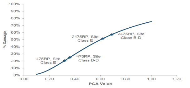
Estimates were developed for four levels of shaking hazard, two of which are used in this analysis. These levels correspond to Peak Ground Accelerations (PGA) (g) for 475 and 2,475 year return periods.
Aplicación de la teoría de la probabilidad
This historical information is used to develop estimates of the regional tectonic setting near Barbados, based largely on past studies such as Bozzoni et al (2011). Site specific estimates of the ground accelerations in Barbados are based on Salazar (2013), while the consequences of the seismic activity introduces another set of site specific parameters related to the type and quality of construction in Barbados.
- The history of seismic activity in Barbados is limited.
- There are various ways to characterize ground acceleration, of which some are more dependent on the soil class, while others are less influenced. Liquefaction was not considered in the NCRIPP study due to the need for localized and specific soil data, which was not available for this study.
- ...
- ...
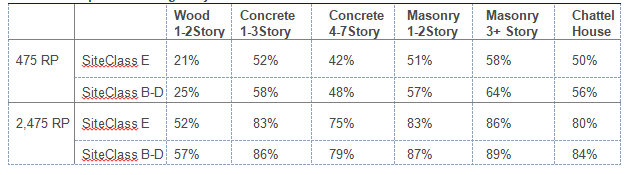
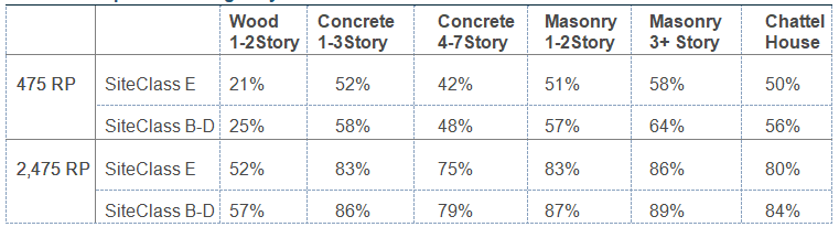
Estimates of damage are developed for each structure based on a Low-Code assumption, the number of stories, building material, and the site class the structure is built on (i.e. the PGA value it experiences at the return periods). Within the HAZUS software, four lognormal probability distributions are associated with each of the 36 building types where the complement of these four distributions is interpreted as no damage. Using Equation 7.1, a cumulative probability distribution is created for each damage state, where the input is the log transformation of the PGA value.
For each of the six structure types represented in the analysis, all four cumulative probability distribution were constructed, where the distribution represents the probability that the structure will be damaged at least to the given damage state. Figure 7.3 shows the four damage state distributions and the “None” damage state for one story, wood structures.
The probability of a structure experiencing a specific damage state is then calculated by taking the difference between cumulative distribution functions at a specific PGA value of interest (demonstrated below). In our case, the PGA values used are the four PGA values for the two site classes and two return periods.
Utilizing the tax parcel and LiDAR data, every structure on the island was identified as low-rise, mid-rise, or chattel house and assigned a site class based on spatial analysis.
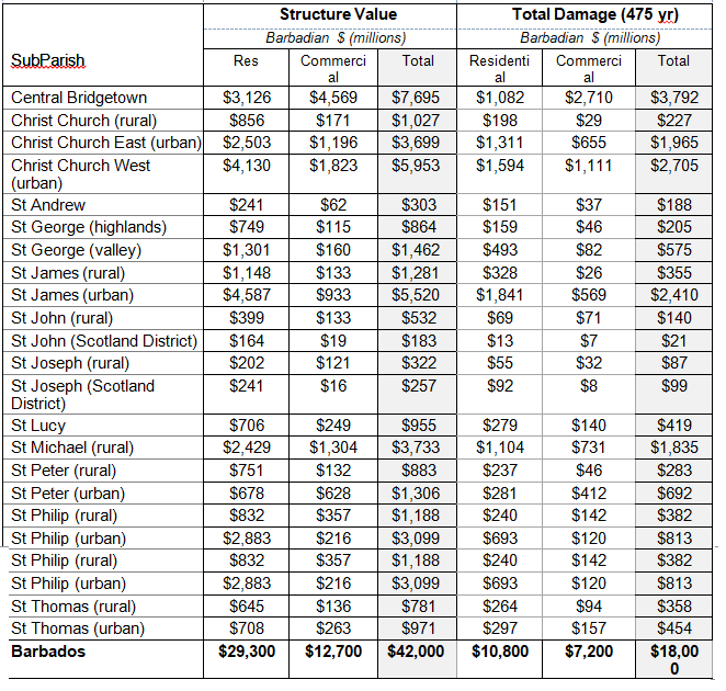
Content damage was included at a rate of 50% of the structural damage for residential structures, and 100 % of the structural damage for commercial structures.
The scope of casualties considered includes expected deaths directly caused by structural damage, but excludes mortality from heart attacks, car accidents, falls outside of a structure, power failure, rescue and restoration efforts, or indirect effects such as fires, dam failures, landslides, or tsunamis.

This analysis relies on assessments of seismic hazards as estimated by Golder Associates (Baird, 2017a). Estimates were developed for four levels of shaking hazard, two of which are used in this analysis. These levels correspond to Peak Ground Accelerations (PGA) (g) for 475 and 2,475 year return periods. Vulnerability also depends critically on the seismic building code of structures. Based on the HAZUS methodology to characterize the local building code: high code, moderate code and low code, they have been evaluated assigning the structures of Barbados a Low-Code designation.
- ...
- ...
- ...
- the detail of the structure characteristic data available for Barbados also limits our ability to accurately attribute detailed building types to structures in Barbados.
- many of the building types show similar vulnerability to the ground shaking hazard, suggesting that differentiation among multiple building types is less valuable for these similar categories of building vulnerability.
- Damages are assessed based on the expected damage to a structure given the probability it falls within each of five damage states: none (no damage to structure); “slight” (5% of structure value damaged); “moderate” (20% damaged); “extensive” (75% damaged); and “complete” (100% damaged).
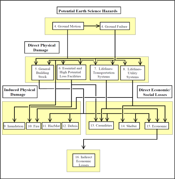
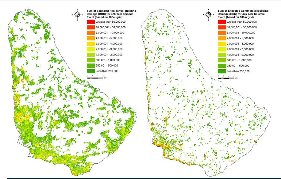
Seismic hazard prevents hazard analysis from providing more than a first-order assessment of potential seismic damage. The main objective of the assessment is to provide a first estimate of the damage potential for each of the two available return periods, which will make it possible to compare the potential for seismic risk with the estimated damage in other hazard categories. The spatial distribution of the seismic hazard is represented by 100 m plots. For commercial damages, the location of assets is much less distributed compared to residential damages, resulting in larger differences in values. In general, the seismic damage approach applied here can be applied to estimate losses for an individual building, since it is the characteristics at the structure level that define vulnerability to seismic damage. Also, in the absence of data, we have no means to assign night workers to workplaces, so they are all assigned to residential structures, which probably overestimates the mortality risk of the residential structure for that scenario.
- at return periods in the comparative range of 10 to 100 years, there is little documented seismic activity or damages of any significance. b. There is little history of seismic damage in Barbados, which suggests that the seismic risk at the 50 year level would be very low and far below the flooding risk.
- There is little history of seismic damage in Barbados, which suggests that the seismic risk at the 50 year level would be very low and far below the flooding risk.

- The main goal of the assessment is to provide a first estimate of damage potential for each of the two return periods available, which will allow for a comparison of seismic risk potential to estimated damages in other hazard categories.
- Knowing the age of the structure can help assign an expected code adherence. Knowledge of structure age may assist in assigning an expected code adherence.

- ...
- ...

